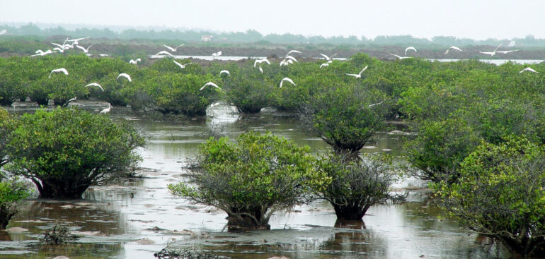
Xuan Thuy National Park (Nam Dinh) – Photo provided by the National Park
Xuan Thuy National Park in Giao Thuy District, Nam Dinh is a fertile alluvial area south of the Ba Lat estuary of the Red River with a total area of about 7,100 hectares. The wetland area here is home to a population of typical wetland flora and fauna in the Red River Delta with a habitat for more than 215 species of waterfowl, many of which are listed in the world’s Red Book such as: Spoon-billed stork, spoon-billed plover, yellow-billed grebe, red-headed heron, pelican, seagull, etc.
Xuan Thuy National Park has 120 species of vascular plants, of which nearly 20 species are adapted to flooded conditions, forming thousands of hectares of mangrove forests. The forests here contribute to the stabilization of alluvium to create new alluvial plains, act as nurseries and provide food for aquatic animals, and play a role in ecological balance in the area. Floating plants have 111 species, many of which are algae of high economic value such as Golden thread seaweed.
Every year, about 100 species of migratory birds choose this place as a stopover on their journey south to avoid the cold, including 1/5 of the world’s spoonbills. Spoonbills are water birds with a unique spoon-shaped beak, and there are not many left in the wild, perhaps that’s why their image is used as a symbol of Xuan Thuy National Park. With its outstanding global values, in 1989, Xuan Thuy Wetland was recognized as the 50th Ramsar site in the world and the first in Southeast Asia, meeting 6/9 criteria of a Ramsar site.
In 1992, the People’s Committee of Xuan Thuy district established the district’s Center for Environmental Resources to help the Government fulfill its commitment to the international community on the conservation of internationally important wetlands in Xuan Thuy.
In 1992, the Ministry of Labor, War Invalids and Social Affairs approved the Con Ngan sea encroachment project, including: “The submerged land area from Vanh Luoc Dike to Ngu Han Dike is divided into 04 blocks to be able to plan the construction of a new economic zone for 03 new communes.”
In 1995, the Ministry of Forestry (now the Ministry of Agriculture and Rural Development) approved the Technical Economic Dissertation of Xuan Thuy Wetland Nature Reserve; after that, the Nam Ha Provincial People’s Committee decided to establish the Nature Reserve Management Board under the Nam Ha Provincial Forest Protection Department.
Aquaculture in the area has gone through many ups and downs, from initially focusing on extensive farming of a few main native species such as shrimp, crab, clam to meet the local market to expanding the scale of farming (increasing area, number of species and farming intensity…) for export purposes. The project of the Ministry of Labor, Invalids and Social Affairs changed the goal from reclamation of the sea to establish 3 new communes to aquaculture for the purpose of commodity production. Therefore, a new commune corresponding to Giao An commune, Giao Hung commune (1997), was canceled by the Prime Minister in 2003. The tradition of reclamation of the sea was also changed to: “parrots encroach on the sea, shrimp encroach on parrots”.
Mangrove forests also have a rather complicated history of formation. Initially, it was just a spontaneous movement to plant Vết (Trang) to protect sea dykes, then the locality received small grants from the Government and international organizations. In 1995-1998, mangrove forests were planted with funding from the Greening of bare hills (Program 327), from 1999 to present, the Program to plant 5 million hectares of new forests (Program 661). Especially from 1997-2005, the Danish Red Cross sponsored Giao Thuy district for the Mangrove Restoration project with a scale of planting thousands of hectares of RNM and achieved quite positive results. Casuarina forests were planted mainly on the outer edge of Con Lu and the sand strip on the outer edge of Bai Trong with the above funding sources. In 1999, the area of stable casuarina forests reached over 100 hectares. In recent years, due to the impact of storms and rising sea levels, the Casuarina forest has been greatly reduced. The forest area has been reduced to only about 50 hectares, concentrated on the outer side of Con Lu.
In 2002, Vop Dam was connected to Vop Bridge, and at the same time, a series of drainage channels were opened along Con Ngan, and the water system was regulated more reasonably. 2004 was a good year for natural clams, helping the local community gain a large source of income (hundreds of billions of VND from various clam products). However, in recent years, due to unreasonable farming combined with other objective factors such as environmental pollution and climate change, aquaculture in general in the area has declined sharply. Many shrimp and clam ponds are ineffective, losing revenue, leaving the ponds empty or operating at a standstill, negatively affecting aquaculture and social security in the area.
In 2003, the Government decided to upgrade Xuan Thuy Wetland Nature Reserve to Xuan Thuy National Park.
In 2004, UNESCO continued to recognize the Inter-Provincial Coastal Biosphere Reserve of the Red River Delta, in which Xuan Thuy National Park became the core area of special importance of this World Biosphere Reserve.
Source: Department of Natural Resources and Environment


